Here are descriptions for two more of our day rides, Timberline Lodge Loop and Shaniko/Painted Hills Loop. You can find all of our day rides, including the off-pavement rides here: https://ridewithgps.com/collections/2244945
For this year's BMW MOA Rally in Redmond, the third time we’ve been to Redmond, we’re hoping to take you to some familiar places along with some new places. We’ve been scouring Google Maps since last year finding things we never knew were around Redmond and dreaming of sweeping road rides to scenic places in the high desert region of central Oregon.
 Timberline Lodge Loop
https://ridewithgps.com/routes/46557197
Built in 1936,Timberline Lodge is a National Historic Landmark sitting at 6,000 feet at the foot of Palmer Glacier on the south face of 11,249 foot Mt. Hood. Famous as a ski and hiking destination, it served as the exterior of the hotel in "The Shining." Don’t be surprised if you’re accompanied by skiers as you climb the Timberline Road; you’re riding to the home of America’s longest ski season.
The clockwise route is flat until it climbs to the top of the Deschutes River Canyon at Warm Springs. Don't overlook the Peter Skene Ogden Viewpoint atop the Crooked River Gorge. The high plateau gives way to forest as it ascends Mt. Hood. Gas can be found in Warm Springs, then again in Government Camp.
The return trip follows the old Barlow Road, a segment of the Oregon Trail. At Tygh Valley, the final leg descends into the Deschutes River Canyon before zipping back to the rally site. Interesting distractions along the last leg of the trip include Richardson’s Rock Ranch and the Erickson Aircraft Collection in Madras. It’s a long way to ride to lunch (235 miles r/t), but Timberline is a one-of-kind destination.
 Shaniko/Painted Hills Loop
https://ridewithgps.com/routes/46556560
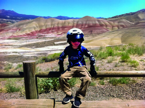
A scenic and twisty tour of the best motorcycling Oregon has to offer. Heading north on US-97 you’ll exit on to OR-293, a narrow, sweeping track that is welcome relief from the superslab. You’re heading to Antelope, home of Rajneeshpuram who made rural Oregon famous while infuriating the local population in the 1980s. Antelope is where the fun really begins. Don't miss the 16-mile out-and-back to Shaniko. If the ice cream doesn't thrill you, the eight miles of perfectly engineered twisties will. Twice.
But that's only the beginning — the 40 miles from Antelope to Fossil will take your utmost attention. Stop at Clarno for a quick hike in the Clarno Palisades. Lunch is served in Fossil — or wait for better fare at Tiger Town Brewing in Mitchell. South of Fossil, you can make up time staying on OR-19. Or you can follow our route to Twickenham (about the 125-mile mark, just before Shelton Wayside Park. Twisting and turning down the hill you’ll cross the John Day River and rejoin the main highway (OR-207) some 22 miles later. After lunch in Mitchell, don't forget the out-and-back to the Painted Hills Overlook. It’s a long day (240 miles) — longer still if you throw in lunch or maybe a hike or two. You can't ask for a better way to enjoy an off-site excursion at the Rally.
 USING RIDE WITH GPS
Ride with GPS is a great way for the MOA to share and distribute maps, GPS routes and turn-by-turn instructions. As with any great service, some best practices in the form of tips and tricks are in order.
- Each route in Ride with GPS is equivalent to a track in the world of Garmin GPS units and BaseCamp software. So for all the routes, make sure you get the entire collection of routes in Ride with GPS.
- Ride with GPS allows you to download many different GPS files types, including GPX, for the BMW Navigator series and other Garmin productsWhen downloading GPX files, only download the "GPX Track" version.
- The "GPX Route" version will leave you at the mercy of the settings on your Garmin GPS, and will take you off the planned route and maybe to unexpected places and road conditions.
- Once you have the "GPX Track" version loaded on your device and want turn-by-turn navigation, convert the "track" on your Garmin GPS to a "trip."
- If you don’t have a dedicated GPS device and use your phone for navigation, Ride with GPS also has a number of file formats to work with various navigation apps for phones.
- Ride with GPS also has its own phone app that will also help guide you! Download now for Apple iOS or Android.
Still Unsure How You’re Getting To Redmond?
If you’re thinking about the Eisenhower Interstate System, then take a look at our Interstate Not So Bliz! article on the BMW MOA Rally website for links that should make the interstate travel less of a drone.


